The Inertial Labs RESEPI Can Now Be Integrated with the Newly Released Livox Avia LiDAR Scanner
This new integration of RESEPI features a compact and lightweight payload ideal for mapping, powerline survey, and more.
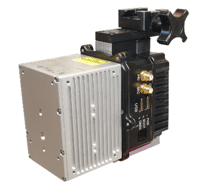
Paeonian Springs, VA: The Remote Sensing Payload Instrument, RESEPI, consists of a dual antenna GNSS-aided Inertial Navigation System (INS), a datalogger, a LiDAR Scanner, an optional camera, and a communications system that allows for real time and post processed generation of point cloud solutions. The RESEPI is now available with the all-new Livox Avia, a compact and lightweight LiDAR scanner that features triple-echo and dual scanning modes. The RESEPI with the Avia is an ideal solution for topographic mapping, precision agriculture, mobile surveying, construction site inspection, and much more.
 One of the key elements that sets the Avia apart from the field is its dual-scanning mode. The device is equipped with both repetitive line scanning and non-repetitive circular scanning modes to meet the needs of different applications. Additionally, the Avia features single, double, and triple return scanning, which further expand the device’s available scanning environments. For forest areas and other natural environments where terrain details are crucial, multiple return scanning will generate a denser cloud of the environment from the canopy to the terrain. The Avia’s impressive maximum detection range, along with the accuracy of the RESEPI’s INS, allows for accurate point clouds at a variety of flight altitudes.
The RESEPI was made with the purpose of private labeling. Inertial Labs’ partners can have their logo on all software, web-interfaces, and hardware. RESEPI is a complete remote sensing solution with all the hardware, software, cables, accessories, and web interfaces available upon purchase. This gives value-added resellers the freedom to focus on developing their business rather than developing the payload product. On the other hand, RESEPI is completely modular. For example, the RESEPI supports other Livox LiDAR scanners, as well as scanners from other top manufacturers like Velodyne, Ouster, and Quanergy. Partners have full control for customization, which can allow them to maintain existing relationships with local suppliers.
Inertial Labs, already the leader in position and orientation sensor technologies, is growing its catalog of innovative solutions at the best value, smallest size, and lowest power consumption in their class. From commerce and industry to government, defense, and aerospace, Inertial Labs is at the forefront of developing and customizing products for exciting technologies, solving today’s problems, and unraveling those of tomorrow.
About Inertial Labs
Established in 2001, Inertial Labs is the leader in position and orientation technologies for both commercial/industrial and aerospace/defense applications. With a worldwide distributor & representative network covering 20+ countries across 6 continents, a standard product offering that spans from Inertial Measurement Units (IMU) up to full GPS-Aided Inertial Navigation Systems (INS), and an application breadth that covers Land, Air, and Sea; Inertial Labs covers the gambit of inertial technologies.
![]()
![]()
![]()

For further information contact:
William Dillingham, Application Engineer
Will.Dillingham@inertiallabs.com
+1 (703) 880-4222
Inertial Labs Inc,
39959 Catoctin Ridge Street, Paeonian Springs, VA 20129
www.inertiallabs.com