Inertial Labs Releases Revolutionary Complete LiDAR Remote Sensing Platform, RESEPI, as a Customizable Solution for Partners
The new RESEPI produces highly accurate colorized point clouds for inspection and mapping applications with industry-leading cost efficiency.
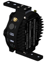
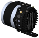
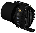
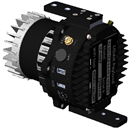
Paeonian Springs, VA: The Remote Sensing Payload Instrument – RESEPI is an ultra-affordable solution for extremely accurate Remote Sensing applications. RESEPI was designed with the purpose of private-labeling, so Inertial Labs’ partners have the ability to put their branding on both the hardware and software components of the complete remote sensing solution. Inertial Labs’ optimized supply chain management and the ability to provide custom integrated solutions, gives any partner the ability to focus on their business, not their hardware or software, with a superior price to performance ratio. With these integration options, RESEPI is the perfect solution for a wide array of remote sensing projects with varying requirements.
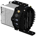
RESEPI is composed of Inertial Labs’ own high-performance Dual Antenna GPS-Aided Inertial Navigation System (INS) with a dual use Novatel RTK/PPK GNSS receiver, and is integrated with a Linux-based processing platform. With an embedded cellular modem, RESEPI supports in-flight RTCM corrections for immediate RTK point cloud generation. In addition, RESEPI can be integrated with a variety of the industry leading LiDAR providers including Velodyne, Quanergy, Ouster, RIEGL, and Livox. RESEPI is also designed to work with RGB cameras such as the Sony A6000 or Blackfly FLIR, as well as thermal cameras to combine photogrammetry with point cloud generation.
"Your LiDAR" Velodyne LiDAR Quanergy LiDAR Ouster LiDAR Livox LiDAR
With Inertial Labs being on the cutting edge of inertial navigation, our INS produces highly accurate orientation and positioning, as a result RESEPI provides paper thin point clouds even at a high AGL. As a small, low power (4W without LiDAR), and ultra-lightweight (0.37kg without LiDAR) system, RESEPI is designed to fit the size and power requirements of any project and allows the user to fly longer and collect more data. In addition, RESEPI’s highly automated software suite with fully automated RTK LAS file generation, along with a 1 click command line interface for post-processing, makes point-cloud generation fast and easy.
About Inertial Labs
Established in 2001, Inertial Labs is the leader in position and orientation technologies for both commercial/industrial and aerospace/defense applications. With a worldwide distributor & representative network covering 20+ countries across 6 continents, a standard product offering that spans from Inertial Measurement Units (IMU) up to full GPS-Aided Inertial Navigation Systems (INS), and an application breadth that covers Land, Air, and Sea; Inertial Labs covers the gambit of inertial technologies.

![]()
![]()
For further information contact:
William Dillingham, Application Engineer
Will.Dillingham@inertiallabs.com
+1 (703) 880-4222
Inertial Labs Inc,
39959 Catoctin Ridge Street, Paeonian Springs, VA 20129
www.inertiallabs.com