 Purpose: To understand the different GNSS correction services that can be used to enhance the performance and precision of the INS-DU.
Last Updated: October 2020
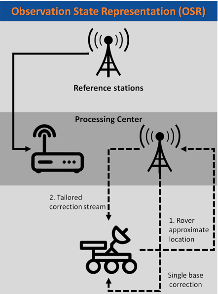
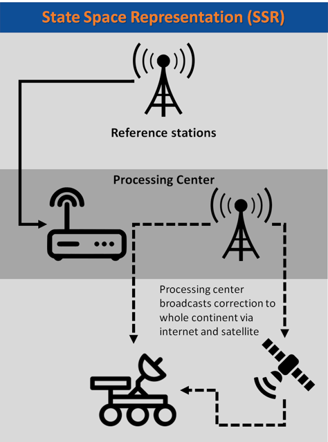
There are 2 different categories of GNSS correction services. These categories are based on either the State Space Representation (SSR) or Observation State Representations (OSR) of the errors. Both categories solve the same problem, but each use different techniques, delivery mechanisms, and core technologies to do so. Both SSR and OSR correction services are used to mitigate key GNSS errors (i.e. orbits, biases, clocks, etc.) in order to enable high precision GNSS performance.
The legacy GNSS correction service providers supply OSR correction services. The core techniques of OSR are centered on transferring corrected GNSS observations from the nearest reference station to the rover. These OSR services will typically use a standardized format of RTCM v3, which are often used for business-to-consumer (B2C) models in specific regions, as well as niche high precision markets such as surveying and machine control.
OSR services are very beneficial for users requiring centimeter-level accuracy while utilizing a rover within 30 kilometers of the nearest reference station. OSR services require two-way communication with high bandwidth, which may make it difficult to use for mass market applications.

Some examples of companies that provide OSR services include: HxGN SmartNet, Trimble VRSNow, TopCon TopnetLive, QXWZ FindCM, and MBC.
State Space Representation (SSR) correction services are the newest generation of GNSS correction services, and are provided by large legacy providers and new entrants. The core techniques of SST are centered around modeling key errors over large geographic regions and transferring them to the rover. The rover uses incoming data from the reference station network to model the GNSS errors, which will then be applied to the GNSS observations directly. The errors transferred from the rover device are the driving force for the performance of SSR correction services.

In addition, the service can be easily distributed over IP and satellite communication channels due to the broadcast nature of SSR corrections. Providers of SSR services have been looking at business to business models so they can meet the demands of large, high precision markets such as in autonomous navigation.
SSR services can achieve centimeter level positioning in large regions while requiring low bandwidth. Due to this, SSR services lend themselves well to mass markets that need high precision positioning. Some major benefits of SSR services include centimeter-level accuracy, global coverage, one-way communication, and low bandwidth. A major drawback of SSR services is that they require proprietary formats.

Some companies that provide SSR services include: QXWZ, HxGN Terrastar X, Sapcorda SAPA Premium, Trimble RTX Fast, QZSS CLAS, and Swift Navigation Skylark.
